The Great Whyte, was formerly known as the Whyte (Wythte, le Withe, le Whygthe) in Medieval times, it runs North from the High Street and Little Whyte. Its name goes back to the 13th-century and is Anglo Saxon in origin. It is probably a corruption of the Anglo Saxon word Waite, which means dock or docking area. This makes sense when you think that all boat traffic used it from Medieval times up until 1852.
It is a peculiarly wide street and has in its width, underneath, a river which flows from beyond the village of Broughton through Wistow, Bury and finally into Ramsey. It then joins the High Lode and Bill Lode North of the Great Whyte, these two rivers (or lodes) flowed into Ramsey from the old river Nene, the Bill Lode no longer exists. The High Street passed over the river via the Great Medieval Bridge or the old High Bridge which is said to have had one pointed arch and was built in the 12th Century.
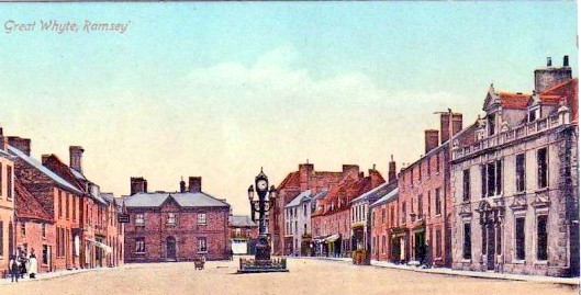
The river that flowed down the Great Whyte was covered over by a tunnel from the NAT West Bank to the chamber near the Memorial Clock. From here it changed to three tunnels, the main tunnel with a smaller side tunnel either side in 1852. The measurement between the buildings on the west side of the street and buildings on the east side measure between 70 – 80ft on average. In the early 1900’s this looked even more pronounced than today, because there was no central island as shown left.
Lidar Map
The river made Ramsey an island in the fens, by cutting it off from the higher land going West towards Bury and Upwood. This is clearly shown in the LIDAR map below.
The Ramsey Chronicler, a Monk of Ramsey Abbey, writing about the Abbey in the 12th century, tells us that
‘Because of the river and all the low lying fens and marshes that surrounded Ramsey it became the ideal place for the building of the Abbey. It remained an island and could only be reached by boat until the 12th century when a causeway was built to link it to Bury and Hepmangrove’.
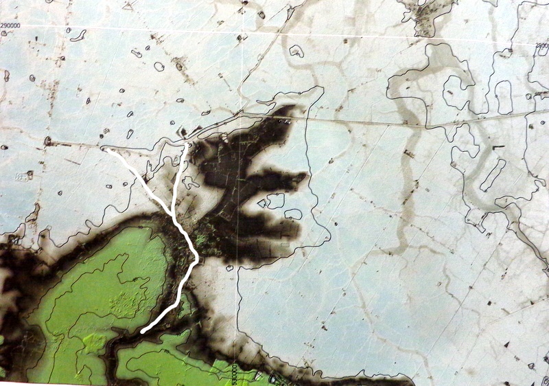 The map shown, is a LIDAR(Laser) map which shows the difference in ground heights above sea level. It plainly shows Ramsey as an Island, which is the dark peninsular shape sticking out from the green coloured area of the higher land to the West of Ramsey. The blue area is the lowest, most at or below sea level, and the grey areas that look like tree roots are the ghostly images of fossilised rivers that existed thousands of years ago. You can clearly see how the island of Ramsey was surrounded by marshes and water on three sides and was effectively isolated from the higher land by the Bury Brook. We have to remember that in Medieval times water and river levels were very much higher than today, then there was no flood defences like we have now. Rivers were tidal and were prone to silting up, which caused the land to become flooded in large areas in the winter and made travel virtually impossible, except by boat.
The white lines show the Bury brook cutting Ramsey off from the higher green land to the left, the white Y shape at the top is the High Lode river which flows off to the right of the map (still existing). The Bill lode which flowed off to the left, no longer exists it was filled in around about the time of the culverting of the bury brook through Ramsey in the 1852. Both rivers joined the old river Nene which flows alongside the road from Ramsey St Mary’s on to Ramsey Forty Foot and beyond. So these two rivers (Lodes) actually flowed into Ramsey not out.
This means that Ramsey had two river arms flowing in from the North and the Bury Brook river flowing in from the South. Which would have made the river levels through Ramsey much higher than we see today.